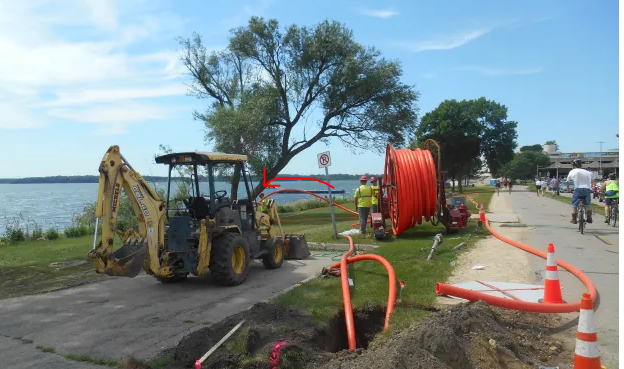
[Photo above and all photos in this post by Maria Powell]
********
Some of this is an excerpt from the end of a previous post (since few will read down that far).
WisDOT Nolen-E. Wilson-Willy St reconstruction testing at Law Park landfill

The 2020 Phase 2/2.5 Site Investigation Report done by the consulting firm TRC for WisDOT before the Nolen-E. Wilson-Willy intersection redesign began (it’s still underway now), includes data and detailed maps from an area that was part of the old Law Park landfill, just south of the John Nolen-Blair-Willy St. intersection.
The map on the right is on pg. 14 (pdf) of the TRC report. This is the eastern end of the old Law Park landfill, which went from Blair to Broom Street. This is the oldest part of the landfill, which began at this location in the 1930s and gradually spread along the shoreline to the west. Here’s what it looked like in 1943.
A large stormwater drain from MGE also travels right through this area and discharges into the lake. This is the same stormdrain where PFAS was discharged into the lake after the MGE fire (see map below).
The groundwater, soils, and lake sediments in this area are likely chock full of PFAS. I wonder how much PFAS is there? Nobody is measuring.
This intersection reconstruction would be a perfect time for the city and/or state to assess how much PFAS is there in soils, groundwater, and lake sediments. But no. Of course not. Nobody wants to know that. Ignorance is bliss.
But TRC investigations in 2020 did find significant PAH (polycyclic aromatic hydrocarbon) and metal contamination in soils and groundwater at this end of Law Park—at levels over several current standards and the DNR’s “Cumulative Hazard Index” or “Relative Potency Factor” calculations, which assess risks from the combination of contaminants present in soils (What are PAHs?). The WisDOT report also included some data from the soil and groundwater contaminant testing done at Law Park in the 1990s, further to the west of the above location, closer to where Monona Terrace was eventually built. Not surprisingly, given that the whole shoreline was a landfill, high levels of PAHs and metals were also found in that testing.
Map from pg. 15 (pdf) of 2020 TRC report (linked above). (The long narrow pink-striped N-S rectangle going into the lake is a large storm drain that drained the PFAS from AFFF firefighting foams during and after the MGE fire. There is still a shallow PFAS plume under MGE that is draining down this stormwater pathway, though nobody is talking about it anymore after DNR deemed it “closed”).

The PAH and metals contamination likely came from the old Law Park Landfill
TRC’s report was clear on where the PAH and metal contamination likely came from. In the section on “contaminated soil management,” the 2020 WisDOT report said the contamination found “is likely associated with former landfill activities at this location…By 1950, the lakeshore had been altered, with 250 to 300 feet of additional land extending into Lake Monona along the Law Park area. From 1933 to the early 1950s, the Law Park area was used as a City landfill.”
Madison Gas & Electric coal ash was used as daily cover on the Law Park landfill. This coal ash is very likely one of the main sources of the toxic metals and PAHs found in this testing and testing in the 1990s (see “What Else Can Hurt Lake Monona” Part II, coming soon)

Because of the high levels of contamination in the soils, the TRC report advised that “Special Provisions should be included in the construction documents advising the contractor of these findings, and the requirements to manage potentially impacted soil…” TRC estimated that ” approximately 2,100 tons of impacted soil will require off-site disposal as direct landfilled material.”
In July 2022, I saw what appeared to be dewatering by contractors (possibly laying new underground pipes along the bike path? See this photo, also posted below, for perspective).
Based on the 2020 TRC document, and the fact that this whole area is a landfill, the soils and groundwater here are likely quite contaminated. Were the contractors taking “special provisions” advised in the TRC report, due to the contamination? Was this dewatering? If so, where was the water sucked up going? To the lake?
Given how shallow the groundwater is in this area, contractors working in this area likely had to dewater during the project, which is still going on. Do these contractors have WPDES permits for these discharges? Who knows?


