Now that the neighborhood class action lawsuit against Kipp is settled [1] and Madison-Kipp has paid a total of $7.2 million dollars to homeowners near the factory, Kipp and government agencies would like all questions about risks to people living, working, and playing on properties adjacent to the factory to just go away.[2] With the Goodman Community Center about to build a children’s splash pad less than 50 feet from one of Kipp’s most toxic areas, unanswered questions about risks to people who spend time at the center, especially children and pregnant mothers, are more relevant than ever.
Just how toxic is the northern part of the Kipp property and the adjacent city property? Here’s a visual summary. Where did these high levels of contaminants come from? Do they pose potential risks to people at the Goodman Center? In a memo on April 30, 2013 (pg. 4) Dr. Lorne Everett, expert in the class action lawsuit, noted:
“Considering the proximity of the Goodman Community Center (immediately north of Madison-Kipp) to high on-site PCE concentrations in soil vapor and given the fact that high levels of groundwater contamination are found even farther north, it appears that groundwater and/or soil vapor under the Goodman Community Center are impacted with Madison-Kipp’s contamination. It would be prudent to conduct soil vapor and subslab sampling at the Goodman Center but the Arcadis report completely omits a discussion of this off-site threat.”
Since the class action lawsuit was settled, even more data has been released that indicate testing at Goodman would be “prudent”—especially before allowing children to frolic at a splash pad just feet away.
Instead, Kipp and government agencies seem to be digging their heads deeper and deeper in the sand. Read on…
High Soil Vapor Results along City of Madison Bike Path
The most recent publicly available data from the northern boundary of Kipp’s property and on the City of Madison property between Kipp and the Goodman Center begs for more testing of groundwater, soils, and vapors on the Goodman property. Three rounds of soil vapor tests (two in 2012, one in April 2013) just south of the bike path on City of Madison property—only about 20-30 feet from where the splash pad will be—have shown increasing levels of vapors in the soil only about 7-8 feet down. In April 2013, the soil vapor probe directly across from the splash pad area (VP-6) showed alarmingly high vapor levels: PCE: 19,000 µg/m3; TCE: 6,100 µg/m3; cis 1, 2 DCE: 8,200 µg/m3; trans-1, 2 DCE: 320 µg/m3; Vinyl chloride: 340 µg/m3.
Shhhhh….Kipp Doesn’t Want Anyone to Notice…
Madison-Kipp seems to be purposely trying to downplay (or hide?) these important results on how contaminated the north side of their property is and how their operations have contaminated the City of Madison property adjacent to it. The most recent soil vapor data was part of the 2013 Kipp Annual Report not released till April 2014.[3] The very high VP-6 results were tucked away at the end of a huge table in a separate document (p. 152) that was not included with the actual Annual Report document, and now doesn’t seem to be easily accessible anywhere. Results were reported in ppbv (parts per billion by volume), which looks much lower than the more standard reporting units of µg/m3 (micrograms per cubic meter).
Oddly, Kipp consultants used the less protective, non-residential screening levels with an attenuation factor of 0.001 for deep soil gas to indoor air (vs residential attenuation factor of 0.01), which allowed these very high vapors levels not to be flagged as exceeding the “Wisconsin Residential Deep Soil Gas Calculated Screening Levels.”[4] Using the deep soil gas, non-residential attenuation factors and screening levels in this context is questionable, for a number of reasons (and depend on who is the focus of the risk assessment—see discussion below). The groundwater at this location tends to be very shallow; in spring 2014 the groundwater was only a few feet down and all the 7-8 feet deep vapor probes on the bike path were under water. Also, the probes are on public property (City of Madison), not Kipp’s property.[5],[6]
Further, the text of the Annual Report doesn’t mention these high vapor probe results and the fact that vapor levels at VP-5 and VP-6 have increased significantly in recent tests. Instead, it states disingenuously that “In general, the 2013 data are consistent with previous vapor probe data.” In fact, the 2013 VP-5 and VP-6 levels are significantly higher than the previous tests. For instance, vapor probe 6 levels for just PCE went from 63 ppbv (413 µg/m3) on 3/3/2012 to 190 ppbv (1245 µg/m3) on 10/26/12 to 2900 ppbv (19,000 µg/m3) on 4/29/13—increasing by 46 times from the first to the third test. PCE breakdown products TCE and vinyl chloride, which are even more toxic than PCE, also increased significantly at this probe and at VP5. The obscure placement of these results, use of deep soil gas attenuation factors and non-residential screening levels, use of ppbv instead of ug/m3 in reports, and dishonest discounting of them in the Annual Report seem to be attempts to make it more likely that the few people who ever see find these results buried in reports will skim over them without notice.
What Potential Exposures are Being Assessed? Exposures to Workers, Children at Goodman, or Anyone At All?
The kind of attenuation factors and screening levels risk assessors choose typically depend on whether nearby buildings (into which vapors might enter) are industries, businesses, homes, schools, community centers, etc.—which in turn determines what kinds of people might be exposed to vapors and to what extent.
If the goal is to assess vapor risks to workers in the Kipp factory, non-residential attenuation factors and screening levels would be more defendable (though still problematic).[7] However, the original reason for the probes along the bike path, as far as we understand (based on our conversations with Henry Nehls-Lowe at Department of Health Services),[8] was to explore, moving outward from Kipp, how far vapors extend away from Kipp towards Goodman Community Center. The more protective residential attenuation factors and screening levels are typically used for schools, daycares, and community centers such as Goodman. In other words, if the goal is to assess potential risks to people at the Goodman Center building, the residential attenuation factor of 0.01 should be used—which would put these levels well over the residential screening levels, indicating that more testing should be done.
Why are the vapor probes along the bike path in the first place?
While the levels found at vapor probes along the bike path raise big red flags about the Goodman property, because they suggest that there is a strong contaminant source nearby, they do not tell us whether or not vapor intrusion might be occurring inside the Goodman Community Center building.
EPA’s OSWER Draft Guidance for Evaluating the Vapor Intrusion to Indoor Air Pathway from Groundwater and Soils (Subsurface Vapor Intrusion Guidance (OSWER is the Office of Solid Waste and Emergency Response) [9] recommends that buildings be assessed for vapor intrusion when they are “within approximately 100 ft laterally or vertically of known or interpolated soil gas or groundwater contaminants” and the “contamination occurs in the unsaturated zone and/or the uppermost saturated zone.” (p. 16). The EPA OSWER guidelines also highlight that “It is important to consider whether significant preferential pathways could allow vapors to migrate more than 100 feet laterally. For the purposes of this guidance, a “significant” preferential pathway is a naturally occurring or anthropogenic subsurface pathway that is expected to have a high gas permeability and be of sufficient volume and proximity to a building so that it may be reasonably anticipated to influence vapor intrusion into the building. Examples include fractures, macropores, utility conduits, and subsurface drains that intersect vapor sources or vapor migration pathways.”(emphasis in original) Building conditions, weather, water table fluctuations, other buildings, barometric pressure, and all sorts of other factors can also influence vapor intrusion in buildings. In some contexts buildings further away from deeper groundwater sources can have more vapor intrusion problems than those closer to sources.[10] Give all of this, repeated tests in the subslab of the Goodman building (which is within 100 feet of contamination on Kipp and city property) in several locations in the building over time (in different seasons) would be the more appropriate way to assess, or rule out, vapor intrusion and potential exposures to people there.[11]
Kipp, Wisconsin Department of Natural Resources (DNR), and Department of Health Services (DHS) have repeatedly claimed that the groundwater contamination under Goodman is too deep to cause vapor intrusion. However, to date, as far as we know, just two groundwater samples have been taken on the Goodman site– from only one shallow depth (7-17 feet) from a well far from the Goodman building on the east side of the property. The August 2013 sample found PCE at 1.4 µg/L, and the October 2013 sample was less than 0.17 ug/L PCE. Based on this, Kipp’s CEO Tony Koblinski assured the public in his March 19, 2014 presentation (Part 2, 15-16 minutes in) that they had verified, with a “no detect” that “there isn’t any PCE in the shallow groundwater that would cause a soil vapor concern” at Goodman. These limited groundwater results, at one depth, hundreds of feet from the Goodman building, are nearly meaningless as far as assessing vapor intrusion there.
Also, as far as we know, Kipp has not investigated any potential preferential pathways, such as sanitary sewers and storm sewers, electric and gas lines, etc., all around and in between Kipp and the Goodman Center that could have routed shallow level contamination offsite, causing soil and groundwater contamination and/or vapor intrusion along these conduits. Mapping these preferential pathways is supposed to be one of the very first steps in developing a “Conceptual Site Model” (CSM) in the initial stages of site investigations for VOC contaminated sites (as MEJO and our collaborators pointed out to the DNR/DHS/PHMDC/Water Utility and city engineering team when we met with them in February 2012).
Do government agencies really think enough is known to rule out vapor intrusion at the Goodman Community Center, from contaminated groundwater and/or shallow soils on Kipp’s northern boundary, or both? Interestingly, DNR’s vapor intrusion expert Terry Evanson, in an April 15 2013 memo reviewing Kipp’s Site Investigation report, stated that: “The vapor pathway, including all buildings at risk, both on and off-site, needs to be addressed in the SI” (site investigation) (highlights added). Yet as of spring 2014, even with the planned splash pad, neither Kipp nor DNR have any intention of testing soils, soil gas or vapors anywhere near or in the Goodman building—or groundwater beneath it. Just as troublingly, soils on the site, which had significant contamination due to past industrial activities, haven’t been tested for contaminant levels since before the site was remediated (no confirmation/post-remediation soil testing was done by the consultants).[12],[13]
We are not surprised that Kipp is denying that there could be problems at Goodman related to their operations. We are not surprised Kipp is ignoring evidence, scientific studies, and government guidances on assessing pollution and health risks. We are not surprised that Kipp is not very concerned about environmental laws or exposing children to toxic pollution. But why do some government agencies seem to be going along with this approach as well? Perhaps it is because Kipp’s law firm Michael Best and Friedrich advised them to stay away from the City of Madison public property adjacent to Kipp as well as the Goodman Center?[14] Perhaps all these entities are worried about the messy political can of worms a more thorough investigation of Goodman site might uncover, because Kipp has supported Goodman Center financially for years and City of Madison property is in between Goodman and Kipp? Perhaps they don’t want anyone to uncover the evidence that Kipp lubrication division, KLS Lubriquip, which used PCE, operated and/or stored materials at the Goodman site in the past (see our previous article)?
What’s the Vapor Source for High Levels Along Bike Path?
The increasing contaminant trends at the two vapor probes (VP-5 and VP-6) along the bike path strongly indicate that there is a high contaminant source nearby. What might it be? Contaminated groundwater was just inches below Vapor Probe 6 when the April 2013 vapor tests were done, so contaminant vapors may have come from the groundwater itself. Though shallow VOC levels at the nearest water table well (Well 1) in 2012-2013 tests were not particularly high, in levels at Well13, just feet to the south of that, have been consistently the highest at the sight (though the shallowest measurements are 44 feet and the water table is well above that). However, Kipp has not shared all the data about groundwater results near these vapor probes. Groundwater data from “temporary wells” on the Kipp site in 2012, never shared with the public, showed the following levels at B51, at the northeast corner of the Kipp building, not far from VP-6: 1500 µg /L PCE, 500 µg /L TCE, 4078 ug/L cis/trans DCE, 890 ug/L vinyl chloride. These results are particularly concerning because of the very high levels of PCE breakdown products (TCE and vinyl chloride), which are considerably more toxic than PCE.[15] It is not clear how deep these tests were.
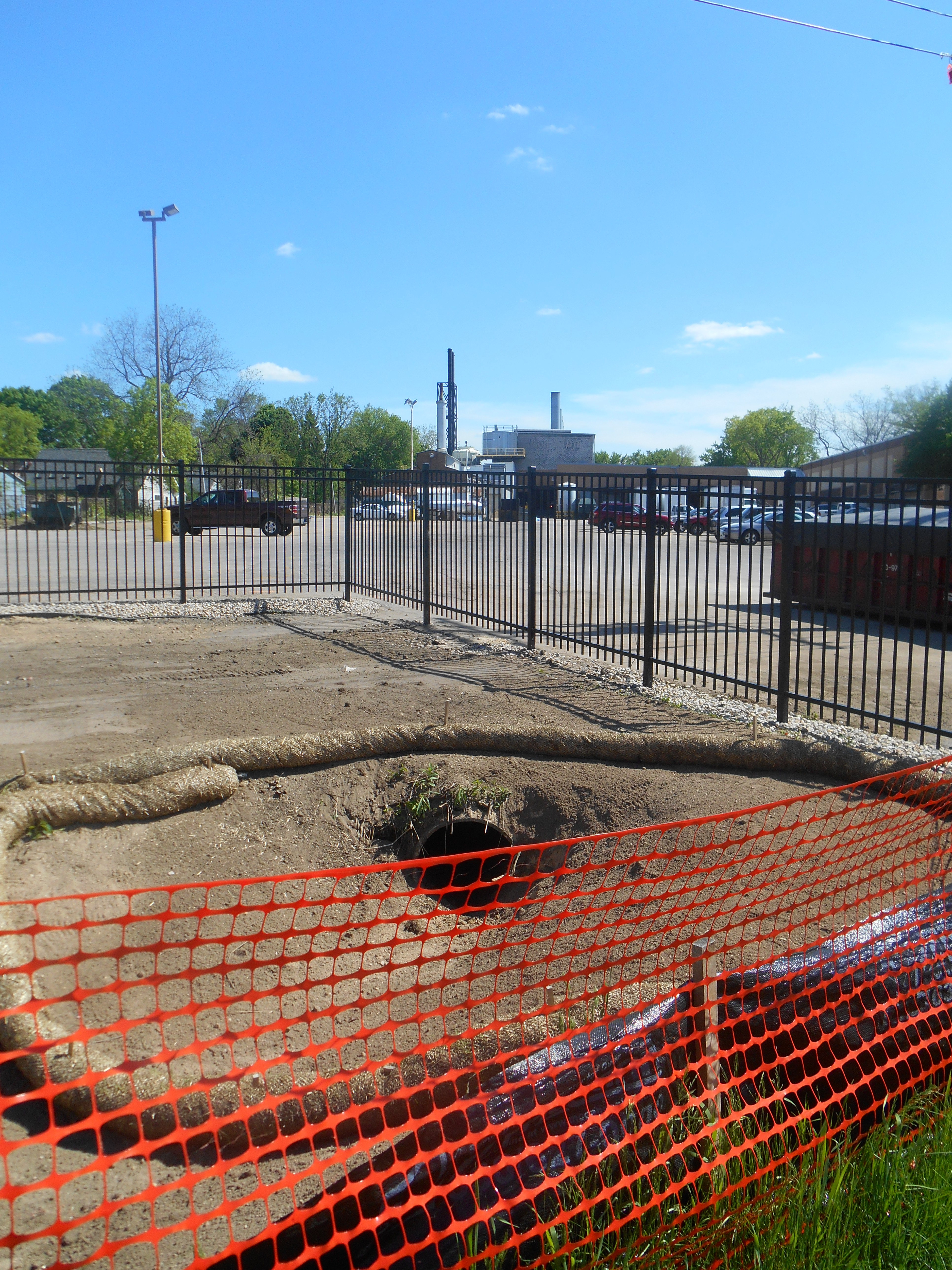
In addition to groundwater, there is another likely source of the contaminated vapors at VP-5 and VP- 6—highly contaminated soils along the former storm sewer that runs from the contaminant hotspot on the northern edge of the building, along the northern edge of the property, and empties into the former raingarden. The end of the pipe that emptied into the raingarden, uncovered in the most recent excavation of the raingarden (see photo above), emptied much of the highly contaminated wastewater from Kipp’s processes into this area for many decades. Several other storm sewer pipes—most likely including some from the contaminated areas further south on the Kipp site—drain into this pipe.
Where did the contamination that went into the ditch and storm sewer come from? According to the 2012 deposition of former Kipp “environmental manager” Jim Lenz during the recent class action lawsuit, there were storm drains all over Kipp’s northern parking lot. Apparently Kipp built storm drains purposely routed north, which joined together into one pipe that emptied into the rain garden area (which then routes runoff to the northeast corner of the property). The contamination entering this “contaminant watershed” came from leaking above ground PCE tanks that drained into the ditch, vapor degreasers along the east side of the plant that vented outside (condensing contaminants onto the soil), and other contaminated areas on the site. Some PCE and various other wastes were purposely dumped outside by Kipp workers, and according to Mr. Lenz one dumping area was off the northern corner of the building (near the northern end of the ditch that connected to the storm sewer pipe). After the parking lot was paved, the oils on the parking lot, which included PCBs, PCE, and other contaminants, ran off to the north over the surface and via underground storm sewer drains.[16] There is evidence that Kipp employees continued to dump chlorinated compounds and other toxic wastes into storm and sanitary sewers through the 1990s if not longer.
Kipp Waste Ditch and Storm Sewer Were Focus of Investigations in the 1990s
Though most recent documents cite 1993-94 as the first discovery of Kipp’s groundwater and soil contaminant problems, engineering consultants (and likely DNR and Kipp as well) knew Kipp might have a groundwater problem when testing at the Kupfer Ironworks site in1986 found some chlorinated compounds in groundwater that were attributed to Kipp operations.[17] It isn’t clear what happened after this initial discovery of chlorinated compounds at the Kupfer site, but in 1993 PCE was found at the Brassworks property and again attributed to Kipp. In 1994, the DNR asked Kipp to formally investigate the contamination, after which a series of investigations by Kipp consultants Dames & Moore was launched.
Dames and Moore’s investigations focused on the northern ditch and storm sewer through the 1990s, after which these sources abruptly disappeared from reports. Dames and Moore noted in one of its first reports, on Dec. 14 1994, that “It is probable that the chlorinated VOCs discovered in the soils at the Madison-Kipp site is (or was), within the “watershed” which contributes to the ditch.” (italics added). Reports clearly diagramed the location of the ditch and storm sewer (e.g., 1996 Dames & Moore Kipp report, March 1997 Dames and Moore report and May 1997 Dames and Moore report; downloading documents can take some time).
All the consultant reports throughout the 1990s outline extremely high levels of soil, soil gas, and groundwater CVOCs (chlorinated volatile organic compounds) as well as benzene, xylene, toluene, and napthalene contamination throughout the ditch and storm sewer area. Reports are clear that the ditch and sewer route were significant contaminant sources that had already impacted groundwater. For instance, the March 20, 1996 Dames & Moore report says: “…soil sample analyses reveal a source area for chlorinated VOCs” in an area “coincident with a former drainage ditch, which extended from the building at the south end (upgradient, adjacent to the former above ground PCE tank), northward until it terminated at the northeast corner of the building. At the terminus, a pipe transferred runoff from the ditch to the storm sewer.” Interestingly, according to this report, the PCE tank “was taken out of service several years ago, the ditch was filled in and the area paved in 1995”[18] (italics added).
The 1995 document reported extremely high levels of CVOCs in soil gas down to 18-20 feet.[19] Consultants admitted that this ditch/storm sewer area is a “source for the transport of chlorinated compounds to the water table” and that “contaminants have migrated into the sandstone bedrock.” However, consultants proposed to do a pilot study on potential remedial options and initiate groundwater extraction and containment.[20]
The March 18 1997 Dames & Moore document reported that the extraction well (EW-1, which appears to be near where MW 13 is currently) along the sewer drain, 10-20 feet off the northeast tip of the factory, had 150,000 µg/L PCE. [21] Again, the report highlights the storm sewer as the source of contaminants. The May 30, 1997 Dames & Moore document, which didn’t mention EW-1,reported stunningly high levels of PCE in shallow soils (2-4 feet) at GP-9, a boring just off the northeast corner of the building: 6,440,000 µg/kg PCE; 126,000 µg/kg TCE; 30,900 µg/kg cis-1,2, dichloroethylene, as well as high levels of benzene compounds, xylenes, toluene, and naphthalene. They also found high levels of most of these compounds 8-10 feet down at this location. Just feet away from that, “beneath a drain pipe which is covered with thick concrete,” where a catch basin pipe joined with the storm sewer pipe, and further along the storm sewer drain, very high levels of CVOCs were found in soils.
Consultants dropped plans for excavating and propose a site specific standard of 1000 ug/kg for soils…
Despite these high levels, consultants concluded that “complete soil remediation by means of excavation” was “technically and economically infeasible” because “the depth of impacted soil (18 to 20 feet) would result in the need for areally (sic) extensive excavation or significant shoring requirements for soil stability” and “utilities and other obstructions would likely prohibit either of these options.” Instead, Kipp and its consultants proposed “a modified excavation” of 8-10 feet of soils in two areas, combined with soil vapor extraction, to remediate soils impacted above “site-specific residual contaminant levels” (RCL). Consultants came up with “site-specific” groundwater and soil RCLs based on equations (from a 1982 paper) and some problematic assumptions about “natural attenuation,” plume size at that time, and groundwater depth. Based on this, consultants recommended a site specific RCL for soils of 1000 µg/kg (or 1 mg/kg)—over 200 times the DNR’s soil to groundwater pathway “residual contaminant level” (RCL) of 4.54 µg/L for PCE in soils.
Kipp’s Northern Hotspot Was Never Adequately Remediated (but after 2000 it disappears from reports)
Oddly, consultant reports after 2000 lack any discussions of the ditch/storm sewer route or any other preferential pathways.[22] Dames and Moore’s 1999 and 2000 reports discounted soil vapor extraction as not feasible “due to the low permeabilities of the soil unit containing the highest concentration of PCE.”[23] Further, the consultants concluded that the previously planned excavation of the two hotspots was “unworkable” because of proximity to the 100-year old building, buried utilities, and because the most contaminated areas were in high levels of vehicle traffic.
Instead, they decided to inject an oxidizing reagent (BiOx) that would “react with the VOCs to chemically degrade them to harmless by-products.” Several bioremediation treatments were done in 1998 and 1999, and verification samples were taken in 1999. The March 21, 2000 report highlights a significant reduction in PCE concentration, but after the BiOx treatments, several verification samples still exceeded the 1000 µg/kg site specific RCL for PCE significantly in the northern hotspot area. The GP-9 area off the northernmost corner of the building had 329,000 ug/kg after remediation, 329 times Kipp’s site specific RCL and over 72,000 times the DNR’s soil to groundwater pathway RCL. PCE breakdown products were also present in significant quantities after the treatment, as were petroleum constituents.
Regardless, after the 2000 report, testing along the storm sewer route seems to have stopped. The ditch and storm sewer were no longer included in maps and diagrams in reports, and there are no further discussions of this major source area on the northern part of the site. During the 2000s, reports occasionally referred to a “former source area” or “previously defined source areas,” and a couple mentioned successful remediation there, but they did not identify or map where they were, or report any data from the storm sewer area.
All attention instead shifted to another source area (the former degreaser vent area) along the eastern side of the plant. This source was significant, and important given the proximity of homes, but the disappearance of any explicit discussions about the ditch and storm sewer was sudden and likely not an accident. Though the BiOx treatment had reduced the levels of contaminants in some particular hotspot areas, levels remained high in soils throughout that area and very high in the groundwater beneath it.[24]
Why did maps and discussions of the storm sewer source disappear? Interrogations in the class action lawsuit deposition of Jim Lenz, an engineer who worked at Kipp during this time, suggest that Kipp’s law firm Michael Best and Friedrich may have instructed the consultants to stop testing along the storm sewer route at some point.[25] Our speculation is that they did not want attention brought to the fact that contamination had likely spread offsite to the north and northeast—including onto and beneath homes, the city bike path property, and the Goodman Center site.
Zoom forward to 2014: Kipp northern hotspot still there (shhhh)…
Whatever caused the shift in focus away from the northern hotspot area and storm sewer over a decade ago, it worked. Government agency staff either never knew about it (because they didn’t bother to read older reports?), or they forgot about it, and/or they were pressured by Kipp and its law firm not to investigate or discuss it. Other than a couple of the larger Arcadis site investigation reports that review the consultant reports from the 1990s, thousands of pages of Arcadis consultant documents avoid explicitly discussing this critical hotspot area and preferential pathway. None of the numerous maps in Arcadis reports diagram the location of the storm sewer and the other storm drain pipes in the northern parking lot that connect to it. Even the reports outlining contamination and remediation of the raingarden, which received wastes from this storm sewer for decades, do not diagram or discuss it. In fact, the 2013 Site Investigation report, absurdly, says “The rain garden captures precipitation runoff from an adjoining bike path”—with no mention of the storm sewer, PCBs coming off Kipp’s parking lot, etc.[26]
As the earlier consultant reports did, Arcadis Site Investigation reports in 2012 and 2013 review the reports in the 1990s that discuss the storm sewer route, but then disingenuously give the impression that the BiOx remediation adequately reduced contaminant levels along the storm sewer route—e.g., the May 2012 report notes: “Enhanced biodegradation was implemented at the two former vapor degreaser vent areas and the former drainage ditch to address impacted soil. Post-remediation sampling indicated that the remedy was successful at decreasing VOC concentrations.” The 2013 report is even more misleading (and in fact, outright incorrect), noting that after remediation, “The data showed that concentrations of PCE were reduced to below the Site-specific residual contaminant level (RCL) of 1 mg/kg established for the remedy.” In fact, several borings throughout the northern area had contaminant levels hundreds of times above 1 mg/kg (1000 ug/kg) after remediation and thousands of times above the DNR’s soil to groundwater RCLs.
Given the above, it is not surprising that significant levels of contaminants remain in soils along the storm sewer route. Moreover, the groundwater in the northern part of the site, in the area where the ditch drainage pipe and older maps suggest that the storm sewer pipes come together, is where the most contaminated wells on the Kipp site are to this day—see the recent plume maps released by Arcadis. Groundwater well MW-13 has significantly higher levels of PCE than any of the other wells (see pg. 16 of above document). Most troubling, groundwater and soil data from the northern area suggest that the BiOx used in the remediation in the late 1990s, rather than breaking the PCE into “non-toxic byproducts” (as consultants claimed it would in their reports), broke PCE down into its far more toxic degradation byproducts trichloroethylene and vinyl chloride. The two northernmost shallow wells near the storm sewer route—MW-1 and MW-13—continue to have very high levels of PCE and its more toxic breakdown products TCE and vinyl chloride.
These results are highly relevant to considering risks to people at the Goodman Center property, much less than 100 feet away from Kipp. Yet, city/county and state public health agencies, and the DNR, have apparently given the stamp of approval to Goodman Center to build a splash pad only about 20-30 feet away from Kipp’s northern hotspot, without even requiring the testing they are required to do according to their “Cap Maintenance Plan.”
Why are they burying their heads in the sand (errr….toxic sludge)?
Questions, comments, corrections, additions? We welcome them–please send to info@mejo.us. THANKS!!
[1] Also see here
[2] In previous stories, we have raised questions about risks to children at the Goodman Community Center just north of Kipp and whether Goodman Center leaders followed DNR laws—see here and here and here. Government officials have repeatedly assured us and Goodman owners that these kids are not exposed to Kipp’s pollution, and therefore are not at risk.
[3] This data wasn’t released until April 2014, a full year after the samples were gathered
[4] In the last revisions of the DNR’s NR 700 regulations (which include vapor intrusion regulations and risk assessments), the state decided to adopt standard/screening levels for VOCs 10 times higher, or 10 times less protective of health, than the previous levels.
[5] Bike path probes are 7-8 feet deep and in the wet spring of 2013, groundwater was 8-10 feet down. Spring 2013 vapor probe data was only available for VP6, just inches above the groundwater, but the others (VP3-VP5) were under water.
[6] This raises further questions about who is actually legally responsible for this situation at this point, and any effects it might have on Goodman property.
[7] However, industrial screening levels for vapor intrusion are completely unprotective of workers based on scientific literature. These levels are highly influenced by industry and corporate lobbying and standards allow workers to be exposed to very high levels of contaminant vapors that are likely to cause health problems over the long term.
[8] Nehls-Lowe is the vapor intrusion expert at the DHS who is the lead person making decisions about vapor intrusion and public health risks at Madison-Kipp and other contaminated sites all over the state. In several conversations with him since 2011 about how DHS is assessing vapor intrusion risks at the site, he explained this step by step approach to assessing the potential for vapor intrusion off the Kipp property, moving slowly outward from Kipp. Mr. Nehls-Lowe does not think contaminated groundwater is a source of vapor intrusion in buildings anywhere off the Kipp site because clay soils act as barriers. He does not think that the EPA conceptual site model document (link below) is relevant to the Kipp situation. He does not believe, based on the existing data, that Kipp’s contamination has caused contaminant vapor intrusion into nearby homes—but that any vapors found in these homes are likely from household products.
[10] Like EPA guidances, DNR vapor intrusion guidances say that testing the subslab of buildings is much more relevant to understanding risks to people in buildings than testing outdoor soil vapors.
[11] See EPA’s 2012 Conceptual Site Model Scenarios for the Vapor Intrusion Pathway.
[12] In recent years, the Goodman Center has done a couple spot soil tests for raised bed gardens along the bike path where soils were removed and replaced before remediation.
[13] Even if Kipp groundwater/soil contamination didn’t exist, children and other people at the Goodman site are exposed to the factory’s significant toxic air pollution (dioxins, chlorine, hydrochloric acid, PAHs, metals, particulates, oil mists from die casting, etc), much of which is uncontrolled and unmonitored. Also, industries formerly at the Goodman site are known to have used chlorinated compounds, including PCE and others. The site was remediated, but consultant documents in the DNR database show it has significant levels of contaminants, including lead, arsenic, and PAHs, remaining in soils below the two feet of new soil added after the contaminated soils were removed. Excavation for the splash pad will remove soils many feet below the 2 feet of “clean” soils placed on top of the contaminated soil. Yet as of May 2014, the DNR had no intention of asking Goodman to test the soils before, during, or after the splash pad construction, even though it is required by DNR’s regulations. Apparently nobody, even the DNR, minds that they didn’t follow these regulations last time they excavated, so this time around the laws don’t seem to matter either.
[14] When the vapor probes along the bike path were first proposed in early 2012, Michael Best attorney David Crass wrote the following in a March 14, 2012 email to Steve Tinker, Mark Giesfeldt, Patrick Stevens, Matt Moroney, Michael Schmoller, Henry Nehls-Lowe, Thomas Dawson, and Linda Hanefeld: “Installation of soil vapor probes is not recommended on the public bicycle path north of the Site for several reasons. First, the public bicycle path is located over former railroad tracks and a railroad right-of-way. It is highly likely that chemicals associated with these uses will be present and negatively interfere with the sampling results. Second, historic PCE use has been documented at the Goodman Center property, which will lead to questions regarding origins of any results and will infect any future decisionmaking regarding the results. Third, soil vapor sampling is only useful for evaluating (or estimating vapor intrusion) if the data are collected near a building. As Terry Evanson has said time and again, soil vapor data is of little consequence in the environment unless it is nearby buildings which can then be of concern. The collection of soil vapor samples in an open area will not provide any additional information on the potential migration of CVOCs into nearby buildings.”
[15] We located it in an open records request.
[16] Kipp consultant documents in the 1990s say this area wasn’t paved till 1995, though other documents say the parking lot was paved as early as the 1970s.
[17] Not surprisingly, many documents written by Kipp or their consultants throughout the years and recently have implied that this contamination was from past Kupfer operations (Kipp is trying to blame someone else).[18] So Kipp decided to pave this over after discovering really high levels of contaminants there? Also, other documents say the parking lot was paved much earlier, in the 70s. And, when was “several years ago”?
[19] Chemicals like toluene are known to degrade materials used in sewer drain pipes—causing contaminants to leach through pipes into the soils (and then groundwater) beneath the pipes.
[20] It is not clear what happened during this time, but presumably Kipp began to extract groundwater, which is why an extraction well (EW-1) appeared on their maps in 1997.
[21] EW-1 is on a map in the 1997 report, but no others after that, other than one mention in the 2005 report. The purpose and depth of this well remain unclear. Was Kipp extracting groundwater from this well from 1997 to 2005 or longer?
[22] DNR only recently started asking Kipp to assess preferential pathways—but so far we see no evidence that Kipp consultants are doing so even now (or if they are, the data is not being shared publicly).
[23] This is quite ironic given that currently (2014) soil vapor extraction is being used to remediate contaminated soils at Kipp, and consultants are implying that it is effective (though there are no data yet to verify this claim).
[24] Interestingly, there was one mention of the northern hotspot in the March 25, 2005 consultant report. Well EW-1 (the extraction well, off the northernmost tip of the plant in the remediated hotspot), was mentioned as having “elevated concentrations of CVOCs” (chlorinated volatile organic compounds). Ironically, it says “unlike other locations where the constituents are typically PCE an TCE, samples from EW-1 yielded elevated concentrations of other daughter products, including cis-1, 2, DCE and vinyl chloride, suggesting that natural degradation is occurring.”
[25] See page 220 of Jim Lenz deposition (pg. 55 of the PDF).
[26] Here’s the full quote from the Feb.12-Jan.13 Site Investigation: “There is a feature identified as a “rain garden” located adjacent to the northeast property line (Figure 2-3). The rain garden is a demonstration project completed by the city of Madison to illustrate how runoff of precipitation in an urban setting can be reduced through the use of vegetated areas. The rain garden captures precipitation runoff from an adjoining bike path. While not a habitat for sensitive species, this area was identified as part of the investigation scoping because rain gardens are designed to retain storm water and facilitate infiltration to groundwater. Care was taken during the investigation to reduce the potential for runoff contacting investigative activities.”
